| Home | Services | Store | Downloads | Articles | Help | ||
|
Astronomy Posters In affiliation with our trusted partner, Amazon.com |
||
|
Skymaps.com/store -- Recommended Books & Products for Skywatchers |
|
New Books •
Star Atlases •
Planispheres •
Getting Started •
Observing Guides •
Telescope Books •
Kids Books •
Sky Myths
Almanacs • History & Artistry • Star Map Prints • AstroPhotography • Telescopes & Binoculars • Media • Astro Calendars |
| As an Amazon & HPS affiliate we earn a small commission (at no extra cost to you) from qualifying purchases |
|
Help Support The Evening Sky Map The Evening Sky Map is designed to help all sky watchers to discover the wonders of the night sky. Monthly editions for Northern, Southern and Equatorial latitudes make The Evening Sky Map a unique resource for users worldwide. Please consider supporting this free service by making a donation or by purchasing recommended products. Thank you. |
| Category >> | Star Map Posters | |
| Beautiful posters and prints featuring maps of the night sky. | ||
|
Star Map Posters -- A Selection of Contemporary and Vintage Designs |
|
Current Posters •
Vintage Posters •
Jigsaw Puzzles •
Out of Print Posters
|
|
Current Star Map Posters | ||
|
| ||
 Glow in the Dark Star Map -- Poster by Maps International 33 in. x 23 in. Click here for a larger view A basic star map showing stars and constellations (some with figures which glow in the dark) for the Northern Hemisphere (from 90° North to 50° South). Suitable for children and adults. Generally good reviews although some buyers state the glow in the dark effect lacks intensity. |
||
 Constellation Night Sky Star Map Wall Decal by Wall Dressed Up 24 in. diameter Click here for a larger view A large star chart showing the constellations and stars of the Northern Hemisphere (from 90° North to 0°). Suitable for all ages. Made from premium grade matte adhesive wall decal material. Removes cleanly. Safe for dorm room walls. Removable and reusable!. Made in the USA. |
||
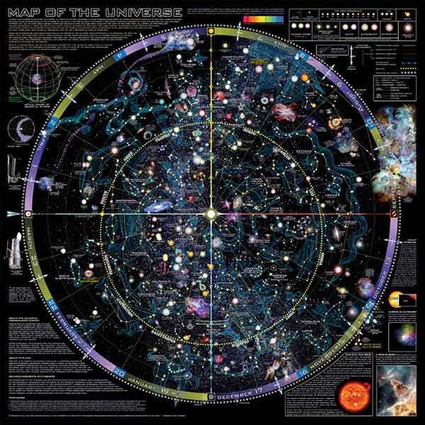 Map of the Universe -- Poster by Spaceshots 36 in. x 36 in. Click here for a larger view A very large star chart showing the classical constellations and the Milky Way of the Northern Hemisphere (from 90° North to 45° South). Includes embedded images of several celestial objects and info panels around the perimeter. Presented as a "God's eye view" (reversed) of the night sky. As such this star chart is not really suitable for star gazing but it nevertheless makes for an interesting celestial display piece. |
||
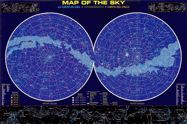
Map of the Sky -- Poster La Carte du Ciel • Sternenkarte • Carta del Cielo by Eurographics 24 in. x 36 in. Click here for a larger view A large double hemisphere star chart showing the northern and southern celestial hemispheres. Color-coded stars to magnitude 5.0 and many deep-sky objects. Includes the Milky Way, constellation lines, and constellation figures (lower portion). Ideal for amateur astronomers and educators. A unique feature of this star chart is the use of English, French, German and Spanish for chart labels. Also available as a jigsaw puzzle. Also available at: Amazon.co.uk (UK) |
||

The Heavens -- Poster by National Geographic Maps 23 in. x 31 in. Click here for a larger view The Heavens star chart poster shows stars and constellations for both the northern and southern celestial hemispheres. The chart includes 2,844 stars visible to the unaided eye, all 88 constellations, the Milky Way, and a number of prominent star clusters, nebulae and galaxies making this chart a great resource for anyone with an interest in the night sky. Also available at: Amazon.co.uk (UK) |
||
|
Skymaps.com/store -- Recommended Books & Products for Skywatchers |
|
New Books •
Star Atlases •
Planispheres •
Getting Started •
Observing Guides •
Telescope Books •
Kids Books •
Sky Myths
Almanacs • History & Artistry • Star Map Prints • AstroPhotography • Telescopes & Binoculars • Media • Astro Calendars |
Copyright - Terms of Use - Privacy Policy - Contact Us Copyright © 2000-2022 Kym Thalassoudis. All Rights Reserved. |